
Tropical Storm Michael now a 75 mph Category 1 Hurricane. Florida Panhandle expected to take a direct hit.
-
At a Glance
- Tropical Storm Michael is strengthening in the northwestern Caribbean Sea.
- Michael will threaten the northeastern Gulf Coast as a strong hurricane midweek.
- Storm surge, damaging winds and heavy rain are likely impacts along the northeastern Gulf Coast.
- Hurricane watches and storm surge watches have been issued along the northeast Florida Gulf Coast.
- Michael rapidly intensified from Sunday morning into Monday morning.
Hurricane watches have been posted on the northeast Florida Gulf Coast ahead of a strengthening Tropical Storm Michael in the northwest Caribbean. Michael could be near major hurricane strength as it approaches the Florida coastline by Wednesday with dangerous storm surge flooding, destructive winds and heavy rainfall.
Michael is currently centered about 90 miles east of Cozumel, Mexico, and is moving northward.
Outer rainbands from Michael are already soaking the Florida Keys, and rainfall totals of 2 to 4 inches are likely there through Tuesday.
Michael rapidly intensified from Sunday 5 a.m. EDT to Monday 5 a.m. EDT when its winds increased from 35 mph to 70 mph in that 24 hour period.
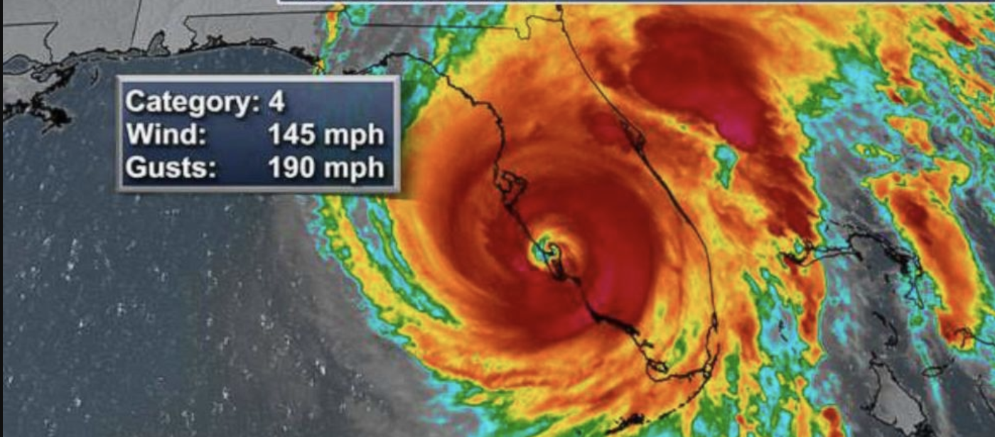
 Current Storm Status
(The highest cloud tops, corresponding to the most vigorous convection, are shown in the brightest red colors. Clustering, deep convection around the center is a sign of a healthy tropical cyclone.)
A hurricane watch is now posted for the northeast Gulf Coast from the Alabama/Florida border to Suwanee River, Florida. This includes Pensacola, Panama City and Tallahassee. Hurricane watches are issued 48 hours before the arrival of tropical-storm-force winds which is when outside preparations become dangerous.
Tropical storm watches are in effect from Suwanee River, Florida, to Anna Maria Island, Florida, including Tampa Bay. Also in a tropical storm watch is a swath from the Alabama/Florida border to the Mississippi/Alabama border as well as inland areas of southern Alabama and southwest Georgia.
 Alerts
(From the National Hurricane Center.)
A storm surge watch has been hoisted from Navarre, Florida, to Anna Maria Island, Florida, including Tampa Bay. This means life-threatening storm surge inundation is possible in the watch area within 48 hours.
 Storm Surge Watches
(From the National Hurricane Center.)
Interests along the northeastern Gulf Coast in the path of Michael should be making preparations. Follow the advice of local officials if you are ordered to evacuate, particularly if you live in a storm surge prone location.
Forecast: U.S. Gulf Coast Threat Midweek
Forecast guidance is unanimous that Michael will be drawn northward through the Gulf of Mexico and pose a threat to the northeastern Gulf Coast by Tuesday night or Wednesday.
 Projected Path
(The red-shaded area denotes the potential path of the center of the tropical cyclone. Note that impacts (particularly heavy rain, high surf, coastal flooding) with any tropical cyclone may spread beyond its forecast path.)
Michael is expected to become a hurricane on Monday and will continue to intensify early this week, potentially approaching major hurricane strength before it makes landfall. This will be due to a combination of increasingly favorable upper-level winds and above average sea-surface temperatures along Michael’s path.
Here’s a general overview of what we know right now.
Timing
– Landfall is most likely to occur somewhere between the Florida Panhandle and the Big Bend of Florida Wednesday into Wednesday night. Depending on how quickly or slowly Michael begins to turn northeast, landfall could be delayed until early Thursday.
– Conditions could begin to deteriorate as early as Tuesday night on the northeast Gulf Coast.
– After landfall, Michael will then move farther inland across the southeastern U.S. into late-week.Intensity
– The National Hurricane Center is forecasting Michael to be a Category 2 hurricane when it makes landfall. However, the intensity forecast is uncertain, and Michael could be slightly weaker or even stronger than that at landfall. There is a chance Michael could be near major hurricane strength ( Category 3+ ) when it approaches the coast.
Wind
– Hurricane-force winds (74-plus mph) could arrive in the hurricane watch area on the northeast Gulf Coast by Wednesday.
– Tropical-storm-force winds (39-plus mph) are most likely to arrive in the tropical storm watch area on the northeastern Gulf Coast by Tuesday night or Wednesday morning.
– Widespread power outages, tree damage and structural damage could occur along the path of Michael near and just inland from where it makes landfall on the northeastern Gulf Coast.
– Windy conditions may extend farther inland across parts of the Southeast as Michael moves northeast, including parts of southern Alabama, Georgia and the Carolinas. Although there is uncertainty with the strength of winds across inland locations, there could be scattered tree damage and scattered power outages. Tropical-Storm-Force Wind Probabilities
(The contours above show the chance of tropical-storm-force winds (at least 39 mph), according to the latest forecast by the National Hurricane Center. Probabilities can increase or decrease over time.)
Storm Surge
– Dangerous storm surge flooding will occur along the immediate coastline near and east of where the center makes landfall.
– Michael is expected to affect portions of the Florida Gulf coast that are especially vulnerable to storm surge, particularly Apalachee Bay south of Tallahassee.The National Hurricane Center says water levels on the coast could reach the following heights if the peak storm surge arrives at high tide:
Indian Pass to Crystal River: 7 to 11 feet
Crystal River to Anclote River: 4 to 6 feet
Okaloosa/Walton County Line to Indian Pass 4 to 7 feet
Anclote River to Anna Maria Island including Tampa Bay: 2 to 4 ft
Navarre to Okaloosa/Walton County Line: 2 to 4 feet Storm Surge Forecast
(From the National Hurricane Center.)
Here are the high tides for Wednesday and Thursday for a few locations in the storm surge threat area (all times are local):
Panama City: 10:30 p.m. on Wednesday | 11:00 p.m. on Thursday
Apalachicola: 4:39 a.m. and 6:10 p.m. on Wednesday | 4:58 a.m. and 7:04 p.m. on Thursday
Cedar Key: 2:48 a.m. and 3:36 p.m. on Wednesday | 3:18 a.m. and 4:19 p.m. on Thursday
Tampa Bay/St. Petersburg: 2:46 a.m. and 4:06 p.m. on Wednesday | 3:09 a.m. and 4:55 p.m. on ThursdayOn the Southeast coast, onshore winds and high astronomical tides will also lead to some coastal flooding this week. Charleston Harbor is forecast to see minor to moderate coastal flooding at high tide.
Rainfall
– Heavy rain is likely to spread inland from the northeastern Gulf Coast midweek to other parts of the southeastern U.S. into late-week.
– Rainfall totals of 4 to 8 inches are forecast from the Florida Panhandle into southern Georgia, according to the National Hurricane Center. Locally up to a foot of rain is possible. This may cause life-threatening flash flooding in some areas.
– Some heavy rain could affect parts of the Carolinas that were devastated by flooding from Hurricane Florence. That said, this system is unlikely to stall like Florence did and will, therefore, not bring extreme rainfall amounts. Some flooding could still occur there, but details are uncertain this far out in time. Rainfall Forecast
(This should be interpreted as a broad outlook of where the heaviest rain may fall. Higher amounts may occur where bands of rain stall over a period of a few hours.)
Tornadoes
– As is typical with landfalling hurricanes, isolated tornadoes will be a threat on the eastern side of the storm.
– A tornado threat may develop in the Florida Panhandle and southern Georgia by Wednesday.Check back with weather.com throughout the week ahead for more details on the forecast for Michael.
Cuba and Mexico Impact
A hurricane warning is now effect for the Pinar del Rio Province in western Cuba. Hurricane conditions are possible there later Monday.
Tropical storm warnings have been posted for Isle of Youth, Cuba, and Mexico’s northeastern Yucatan Peninsula, including Cozumel.
Rainfall totals of 4 to 8 inches (locally 12 inches) are forecast over western Cuba, with 1 to 2 inches over the northeast Yucatan Peninsula.
These downpours could contribute to life-threatening flash flooding and mudslides, particularly in areas of mountainous terrain.